
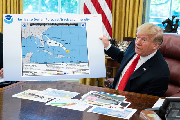
President Trump gave a briefing about Hurricane Dorian and showed a map with what appeared to be a sharpie marker altering the path to show it incorrectly heading to Alabama to match one of his tweets.
President Donald Trump finally spoke out about Hurricane Dorian, but the map he showed to reporters had a suspicious alteration to it that appeared to have been added to support an incorrect tweet by the 73-year-old. On Sept. 4, he showed a National Oceanic and Atmospheric Administration “cone of uncertainty” forecast from 11 a.m. on Aug. 29 that showed Dorian’s projected path from the U.S. Virgin Islands up through the Bahamas and had the state of Florida with the exception of the panhandle circled in white. But then a black sharpie added on a second cone to show it extending into Alabama, which was not on the NOAA’s projection.
Now “Sharpiegate” has taken over Twitter, accusing the president of making a faked extension of the hurricane’s projected path to match one of his tweets. On Sept. 1 as Dorian was battering the northern part of the Bahamas, Trump tweeted, “In addition to Florida – South Carolina, North Carolina, Georgia, and Alabama, will most likely be hit (much) harder than anticipated. Looking like one of the largest hurricanes ever. Already category 5. BE CAREFUL! GOD BLESS EVERYONE!”
The National Weather Service in Birmingham, Alabama then sprung into action half an hour later, correcting the president in a tweet that read, “Alabama will NOT see any impacts from #Dorian. We repeat, no impacts from Hurricane #Dorian will be felt across Alabama. The system will remain too far east. #alwx” Yes, the NWS had to shoot down Trump’s false claim and sure enough, Dorian never made landfall in the U.S. and is currently skirting the eastern seaboard about 100 miles offshore.
The sharpie extension to cover southern Alabama caught the eyes of reporters who questioned Trump about it. The Washington Post‘s David Nakamura tweeted “Reporter just asked Trump about the map: ‘It looked like someone took a Sharpie….’”. Trump: ‘I don’t know. I don’t know.’” David then tweeted, “This cycle will be complete tomorrow when Trump issues a tweet attacking ‘fake news‘ media over its coverage of the altered map…”
People then began making memes with Sharpies mocking things Trump would like to turn into reality. One person used a Sharpie to draw six-pack abs on the president in a photo of him golfing with a big belly. Another used it to add extensions to the small portion of the Mexican border wall he’s had erected.
However, many pointed out that it’s scary that the POTUS would try to pull off such a ridiculous stunt. “People think this is funny but the President just drew on a Weather Service map with a Sharpie to lie to people about where the storm is going – that’s full-blown mental. People aren’t getting it – the president is mentally unstable! He must be removed from office. #25thAmendment,” one man tweeted. Another user wrote “Did he really do this? Did he really extend the path of a hurricane with a Sharpie to prove his false prediction that Dorian could hit Alabama? I feel like I’m taking crazy pills. #25thAmendmentNow.” The 25th Amendment could be used to removed a president from office due to mental incapacitation.